Solar Power Tower Integrated Layout and Optimization Tool
NREL's Solar Power Tower Integrated Layout and Optimization Tool (SolarPILOT™) generates and characterizes power tower (central receiver) systems.
SolarPILOT consists of a graphical user interface and an application programming interface (API) through which external programs can access its functionality. SolarPILOT's calculation engine extends Sandia National Laboratories' DELSOL3 using the computationally efficient Hermite expansion technique, but it applies calculations to each heliostat image rather than to larger groups of heliostats—as DELSOL3 does. SolarPILOT also integrates the SolTrace™ ray-tracing engine to allow cross-comparison of results and analysis of more complex geometries.
SolarPILOT is an open source project and is accepting contributors. You can download source code, view current issues and discussion, or contribute new capabilities at NREL's SolarPILOT Github page. For NREL's official SolarPILOT release, or to view background material, feature lists, or contact information, follow the links below.
SolarPILOT provides state-of-the-art functionality with a number of important features. With SolarPILOT, users can:
- Create heliostat field layouts that account for local solar and atmospheric conditions, receiver geometry and tower height, market pricing factors, and other considerations
- Constrain heliostat field positions with customizable land shapes and easily define complex land-boundary geometry with software that generates KML files (e.g., Google Earth).
- Model a variety of heliostat optical configurations including multiple facets and aiming/canting schemes
- Create systems with multiple heliostat or receiver geometries
- Simulate receiver flux profiles using smart aiming techniques at any specified time or solar position
- Execute parametric simulations to quickly investigate sensitivity to a design parameter
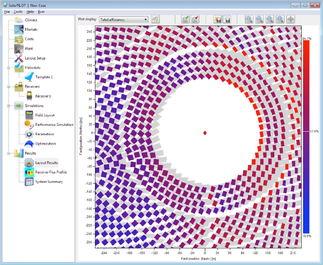
- View field layouts, flux plots, and aim-point plots with an interactive plotting tool
- Optimize the heliostat field layout and receiver dimensions to minimize expected cost of energy
- Calculate solar field cost
- Execute multi-threaded simulations to reduce simulation time
- Execute scripts that provide in-depth control of heliostat positioning, aiming, land boundaries, and calculation procedures.
SolarPILOT was developed with both computational efficiency and accuracy in mind. Systems become more computationally expensive to simulate as the number of heliostats increases, and SolarPILOT has implemented methods to reduce the overall computational burden while generating accurate and precise results. These methods have been developed as part of the U.S. Department of Energy SunShot Initiative research funding at NREL and are made available as part of this software.
SolarPILOT is used by researchers, industry technology developers, and academics to evaluate technology performance, quantify the value of research findings, and provide third-party, independent validation for privately developed tools. SolarPILOT is also used via its API by NREL's System Advisor Model software.

SolarPILOT — version 1.1. Layout Results Page.
Share
Last Updated March 14, 2025
